HobiTech

Counter-UAS Drone Solutions

Introducing Counter-UAS Drone Solutions

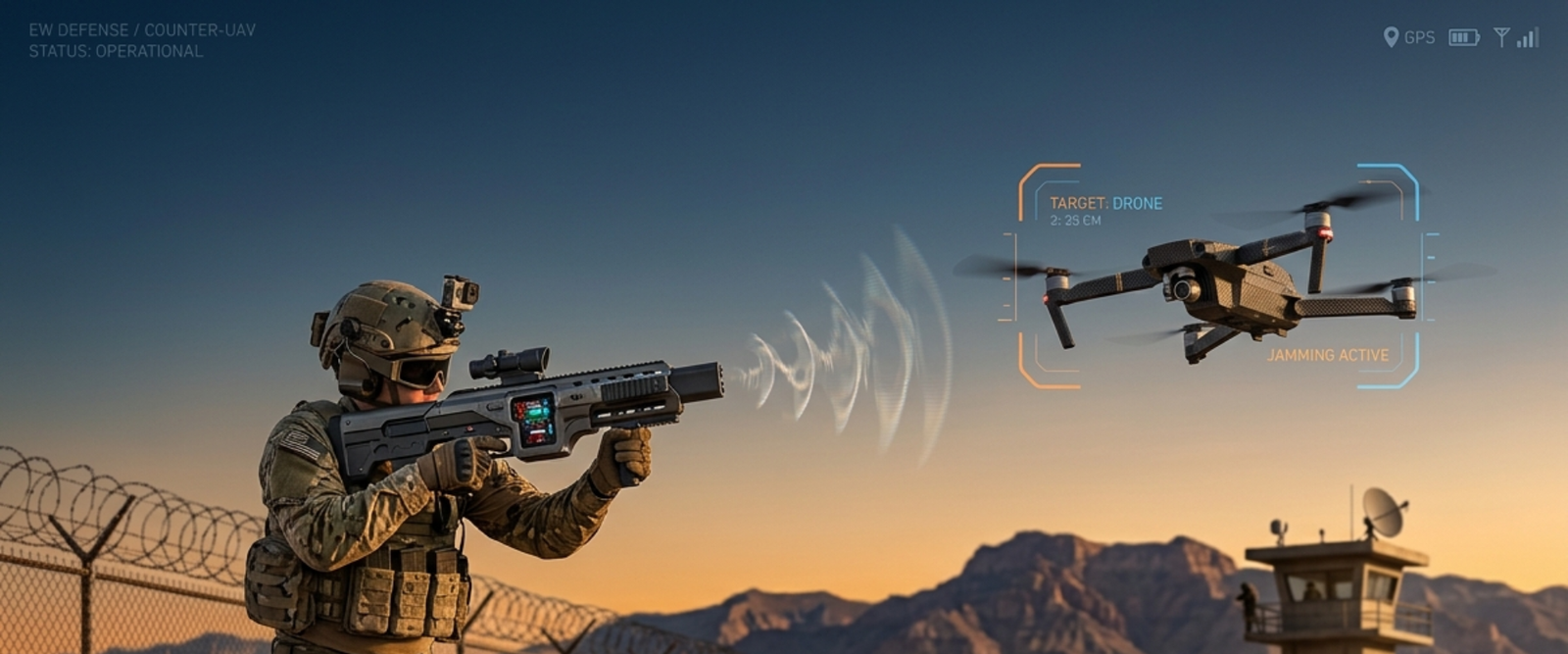
Securing the Skies with Counter-UAS Drone Solutions State-of-the-art Detection, Deterrence & Defence. We protect critical infrastructure from evolving aerial threats with AI-integrated systems. Explore Defence System Comprehensive Ecosystem Integrated security for a drone-filled future. RF Detection Wide-spectrum radio frequency monitoring to identify commercial and custom drone signals before they enter your airspace. Deterrence Soft-kill countermeasures […]

dji avata 360

DJI Avata 360 – What’s New? Full Features, Upgrades & Why It Matters

Buy Now The DJI Avata 360 is one of the most exciting next-generation FPV drones expected to redefine immersive aerial cinematography. Designed for creators, FPV enthusiasts, and tech explorers, this futuristic drone brings 360° video capture, improved flight safety, smarter controls, and cinematic performance into a compact form factor. If you are searching for the […]

DJI Dock 3

Why DJI Dock 3 Is a Game-Changer for Autonomous Drone Operations

Unmatched Durability and Environmental Adaptability The DJI Dock 3 is engineered to operate in extreme conditions, with an IP56 rating for dust and water resistance. It functions reliably in temperatures ranging from -30°C to 50°C, making it suitable for diverse environments—from scorching deserts to icy terrains. The dock’s built-in climate control system ensures optimal operating […]

DJI Matrice 4E

Applications of the DJI Matrice 4E in Surveying and Mapping

The DJI Matrice 4E is transforming the way professionals conduct surveying and mapping. Whether in construction, agriculture, or urban planning, this advanced drone offers cutting-edge solutions for collecting accurate geospatial data with minimal effort. Equipped with high-resolution cameras, LiDAR sensors, and AI-enhanced navigation, the Matrice 4E ensures precision, efficiency, and cost-effectiveness in aerial mapping projects. […]

DJI Flip Drone Review

DJI Flip Drone Review: Is It Worth the Hype?

The drone market has been buzzing with excitement over the DJI Flip Drone, a compact yet powerful aerial gadget designed for both beginners and experienced pilots. With DJI’s reputation for high-quality drones, expectations are high for this model. But does it truly live up to the hype? In this review, we take a closer look […]

DJI Flip Drone

Top 5 Creative Uses for the DJI Flip Drone

The DJI Flip Drone has redefined what’s possible in drone technology, offering users a compact, foldable design packed with cutting-edge features. While it’s known for its portability and advanced performance, its versatility opens doors to countless creative applications. Whether you’re a photographer, adventurer, or tech enthusiast, the DJI Flip Drone can help you explore new […]

DJI Matrice 4 Series

The Role of the DJI Matrice 4 Series in Smart Agriculture and Forestry

The DJI Matrice 4 Series revolutionizes smart agriculture with its precision and efficiency. These drones enable accurate crop monitoring, pest detection, and irrigation management using cutting-edge multispectral and thermal sensors. With detailed aerial data, farmers can make informed decisions to boost yields and reduce resource wastage. This level of precision reduces costs while ensuring sustainable […]

Become a DGCA Certified Drone Pilot

Become a DGCA Certified Drone Pilot

EXPLORE NOW FOR FREE Become a DGCA Certified Drone Pilot: Your Path to Professional Drone Mastery The demand for skilled drone pilots is soaring, with industries such as agriculture, infrastructure, real estate, and cinematography increasingly relying on drones for their unique perspectives and operational efficiency. If you’re interested in becoming a professional drone pilot, enrolling […]

UAV in Forestry

UAV in Forestry

The part of forests in the Earth’s biodiversity has much to do with the planting, nurturing, cultivation, and science of trees, groves, bushlands, and wood thickets, which are the key species of forest ecosystems. The life and soul of our planet, forest ecosystems, make up for 31% of the world’s biodiversity. Being the only elemental […]

Urban Planning using Drones

As drone surveying lays a path toward well-established urban planning, we can quickly accumulate large amounts of real-time data. With extensive aerial mapping technology have benefited government agencies and private developers while designing and analyzing existing social and environmental concerns. Drones: A New Way Of Tackling India’s Urban Planning And Management Issue- Whether it is […]

Product Enquiry

Home
Drones
Accessories
Repair
Call us